Soil and Vegetation Mapping in Temperate Climate Environment, from Fused Landsat TM and Geophysical Data.
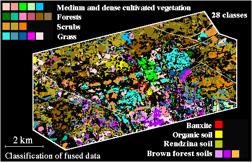
This is a thematic map prepared from fused Landsat TM, gamma-spectroscopy (eU, eTh, K), and apparent resistivity data, with an Artificial Neural Net classifier. Paper in preparation. The first phase of this work is in [Merényi, E., Csathó, B., Gulyás, Á., and Bodrogi, M., 1997, Exploitation of Landsat Images for Mapping Soils and Vegetation in Temperate Climate Environment, Hungary, Submitted to Remote Sens. Environ.]