Land Cover Classification

|
|
|
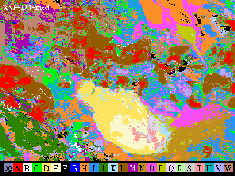
Thematic geologic mapping in arid environment. Soils and rocks of the Luner Crater Volcanic Field, Nevada, based on a 1994 AVIRIS spectral image. 194 spectral bands were used simultaneously. |
|
[Merényi, E., "Precision Mining" of High-Dimensional Patterns with Self-Organizing Maps: Interpretation of Hyperspectral Images, In "Quo Vadis Computational Intelligence: New Trends and Approaches in Computational Intelligence (Studies in Fuzziness and Soft Computing, Vol. 54). Peter Sincak and Jan Vascak, Eds., September, 2000, Physica-Verlag. Hardcover, ISBN: 3790813249] [Merényi, E., Minor, T. B., Taranik, J. V., and Farrand, W.H., 1996, Quantitative Comparison of Neural Network and Conventional Classifiers for Hyperspectral Imagery, In Summaries of the Sixth Annual JPL Airborne Earth Science Workshop, Pasadena, CA, March 4-8, 1996, Vol. 1: AVIRIS Workshop, Ed. R.O.Green] [Merényi, E. (1998) Self-Organizing ANNs for Planetary Surface Composition Research, European Symposium on Artificial Neural Networks, Bruges, Belgium, 22--24 April, 199, pp 197-202].
|
|
|
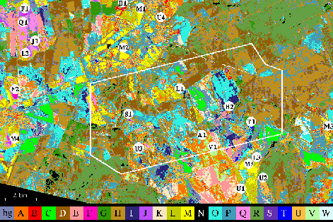
Soil and vegetation mapping in humid, temperate environment, from Landsat TM spectral image, Halimba and surroundings, Hungary. |
|
[Merényi, E., Csathó, B., Bodrogi, M., Gulyás, Á., Exploitation of Landsat Images for Mapping Soils and Vegetattion in Temperate Climate Environment, Hungary, submitted, Remote Sens. Environ..] |