note 1.1![]() AISRP workshop '97 presentation, E. Merényi,
U of Arizona, LPL
AISRP workshop '97 presentation, E. Merényi,
U of Arizona, LPL
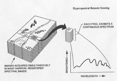
Hyperspectral images consist of a large number of image bands continuously covering certain spectral range(s). The spectral channels of the image bands are typically of uniform width within larger segments of the wavelength window they cover.
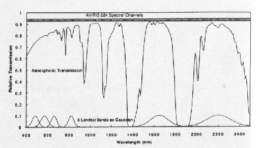
From James B. Campbell, Introduction to remote Sensing, 2nd Edition, 1996.
(Click on this image for a full resolution view.)
This illiustration shows the difference between the bandpasses of a broad band mutli-spectral imager, Landsat TM, and a hyperspectral scanner, AVIRIS. (Green and Simmonds, Summaries of the 4th JPL Airborne Geoscience Workshop, Pasadena, CA, 1993. R.O. Green Ed.)
AVIRIS is the currently most mature airborne hyperspectral imager, operated by JPL/NASA. Its spectral resolution of ~ 10 nanometers is sufficient to resolve the fine absorption features that distinguish most minerals, plants and other surface materials, as seen in laboratory spectra. An AVIRIS image covering ~ 10 x 12 square kilometers is 140 Megabytes of data.
The following two diagrams illustrate the detailed information contained in hyperspectral AVIRIS data, compared to Landsat TM, for a mineral example and a vegetation example. In addition to narrow absorption features hyperspctral data also reproduce the spectral continuum , which sometimes can be more diagnostic of the surface material than the absorption bands.
Mineral example
![]() Vegetation example
Vegetation example
![]()
There is no hyperspectral sensor yet on orbit around Earth. The 2001 orbiter of Mars Surveyer may carry a hyperspectral imager. The first Earth-orbiting hyperspectral imagers are scheduled to fly on the Advanced Land Imager (ALI), to be launched in 1988.
![]()